215 Moffett Park Drive, Sunnyvale CA 94089
(Circa 1970)

|
(A) This is the SVLOPS building, soon after it was first inhabited.
Note the full parking lot, and the absence of any immediately surrounding buildings. This
area has since become the heart of Silicon Valley - it is now close to fully built-up all the way
south around the bottom of the bay and joined to the San Jose megalopolis.
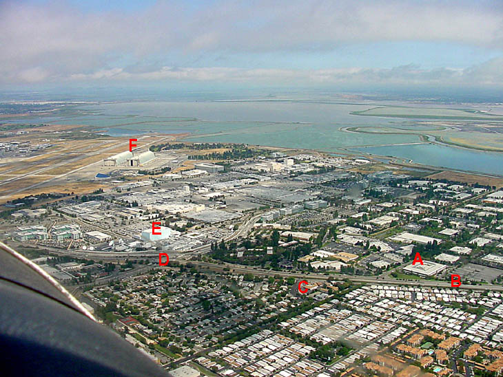
(B) This is Hiway 237 - heading toward Milpitas to the right. (C) The Brass Rail. This was (is) an establishment catering to the beverage needs of Gentlemen. As an added attraction, it featured ecdysiasts with wet T-shirt contests for Amateur Ladies on Wednesday evenings. Its roof gained notoriety in certain circles when some patrons saw fit to use this prime location (next to "The Blue Cube" - see below) to moon an overflying reconaissance sattelite whose top secret mission was to test its powers of resolution. A major security breach - however it is surmised that its powers of optical resolution were insufficient to distinguish any identifying marks on the perpetrators. (D) The intersection of Mathilda and Hiway 237. Also affectionately known as "super light" in honor of the traffic-light complex that controlled this intersection together with its various on- and off-ramps. (E) The Blue Cube. This multi-storey building has no windows at all and its use was veiled in secrecy. It was however common knowledge that had the cold war broken out into a hot war, this would have undoubtedly functioned as "ground zero" for a nuclear warhead. The later addition of a surrounding complex of large dish-antennas together with its later euphemistic name of "Satellite Test Center" provided some clue as to its function. Its proximity to the Moffet Naval Air Station (see below) and Lockheed (its adjacent collection of factory-like buildings) was not thought to be coincidental. The names "NASA Ames" and "Onizuka Air Force Base" were (are) also associated with this general area. (F) Moffet Field. These are the two "smaller" hangars - compare their size to the squadron of P-3 (Orion) anti-submarine aircraft parked just in front. Unfortunately, the really big Blimp hangar is off the picture, beyond the runways to the left.
The Same Scene Three Decades Later(June 2003)
The building (A) was gutted down to the structural girders and refurbished in the 1990's. It is now occupied by a new tenant (Wind River Systems) and the formerly adjacent open fields are now occupied by buildings that house various high-tech companies. Across Highway 237 is now residential - the immobile mobile homes vainly trying to attract a decent tornado. Lucky for them, this is not the mid-west. The Brass Rail is still in operation (so they tell me) but Moffett Naval Airstation is no more. The airfield is still used for some NASA related work, but the wind-tunnels are now in mothballs and the rest of the "campus" is destined for redevelopment into an industrial/research/educational complex.Return to Home Page |