| West Fremont Avenue: Main Artery of Los Altos Hills - A Convoluted History |
|
If we had a "Main Street" in Los Altos Hills today, then it would undoubtedly be "West" Fremont Avenue - the Western end of a much longer roadway that extends
far beyond the borders of just our Town.
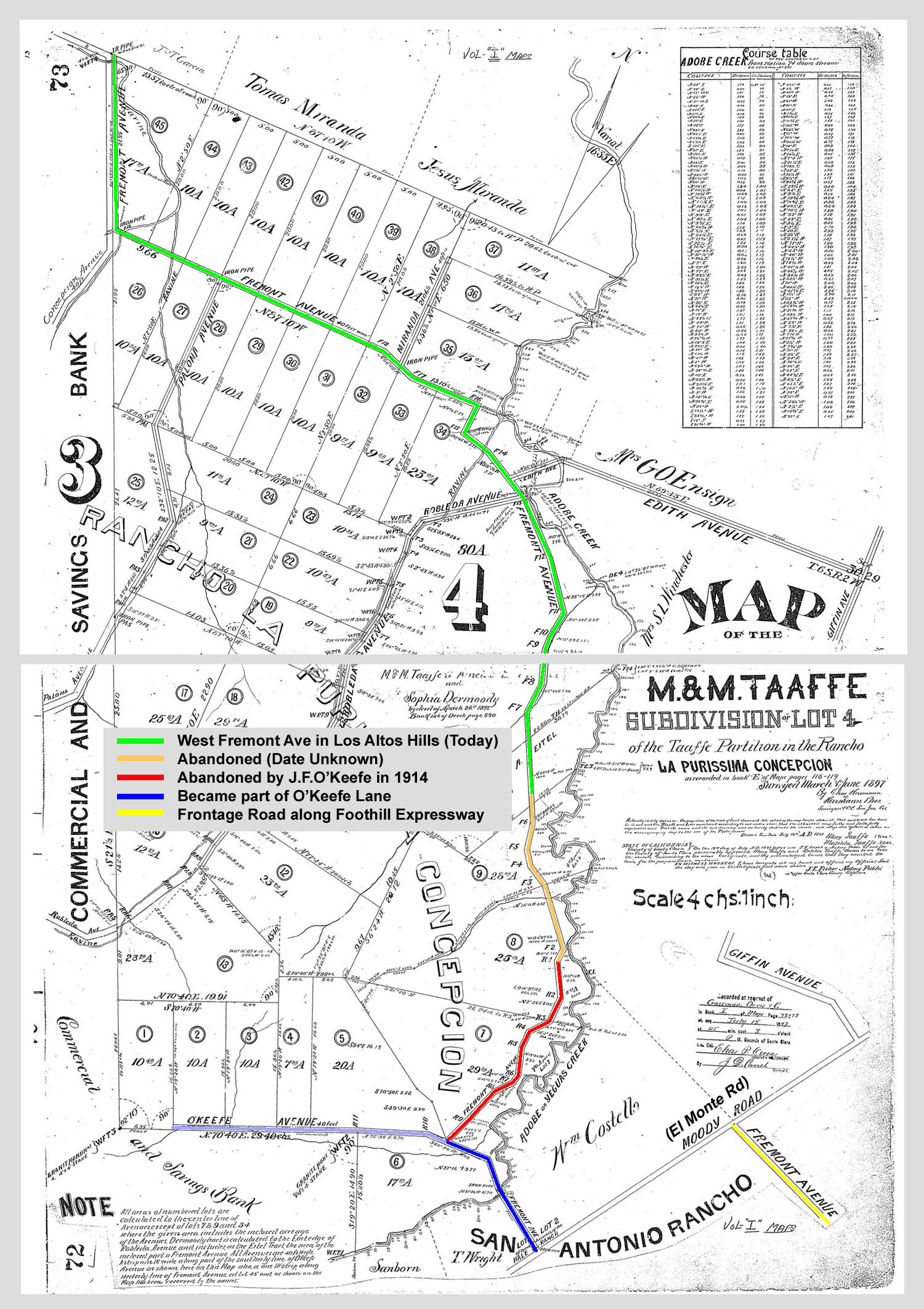
But the Westernmost (and Northernmost) section of this historic thoroughfare embody the heart of our Town. Town Hall and both of the schools that we have in our town are on this road, and it connects to Edith Avenue - arguably our primary connection to the City of Los Altos which plays the role of "downtown" for us. But there is a mystery, or at least a convoluted history behind what we know as "West" Fremont Avenue - part of a greater Fremont Avenue which forms a frontage road all along Foothill Expressway, stretching all the way from the San Antonio intersection and going South all the way through Los Altos, Mountain View, under Highway 85 into Sunnyvale and on... The curiosity lies in the map we have of part of (what would eventualy become) the "Town of Los Altos Hills", but showing that area as it was in 1897. Fremont Avenue existed already then following the route we know today - approaching Town Hall from the North - kinking towards the South-East at its junction with Concepcion at Town Hall, proceeding past Bullis School to the "S" curly bends, and past Edith Park and on past Old Altos Road and curling round to....Ooops - today it comes to an apparent end not too far beyond that. But on the 1897 map, Fremont Avenue continues South and goes all the way down to O'Keefe where it then bends slightly to join what is today called El Monte (but at that time was still called Moody Rd). |
|
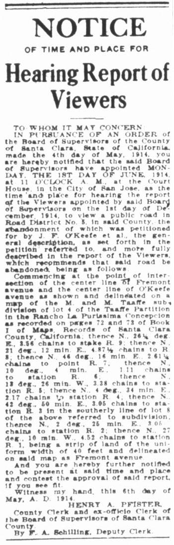
The sections of Fremont Ave as shown on the map above in red and orange, extending north from O'Keefe Ave, do not exist today. The red section was abandoned in 1914 when J. F. O'Keefe led a petition to abandon it.. The orange section was also abandoned, but we don't have any documentation of when that happened - merely the fact that it does not exist today. The following notice from the San Jose Mercury Herald on May 7, 1914 describes the abandonment of the red section. (The left version is the original image we have from the newspaper, the version next to it on the right was created to help with legibility.)
All of the above (the map as well as the evidence of abandonment) was first brought to the attention of these archives by a resident who is close neighbor of Los Altos Hills (Jeff Watt - to whom much thanks is owed for his diligent pursuit), who went further and wrote: Additional digging in the archives showed that the petition of J. F. O'Keefe and others to abandon the section of Fremont Ave was first presented to the county board of supervisors on December 1, 1913 and was referred to Supervisor Michell.
A further interesting question is where the abandoned road sections are in terms of today's geography. Probably purely by coincidence, that section of road would today be just over the border between Los Altos Hills and Los Altos. A coincidence because abandonment occurred in 1914 whereas this border only came into existence when Los Altos became incorporated as a city in 1952 - at that time separating City of Los Altos from County lands. Later on in 1956 it became the border between Los Altos Hills and Los Altos. The follow-up question, is where the abandoned roads would be located in terms of today's visible landmarks . The answer is that the abandoned sections of the original road would have run primarily through the property in Los Altos that is today the Jesuit Retreat Center of Los Altos, located off Manresa Court, and running south to end at what today is Dover Court, a small cul-de-sac off O'Keefe Lane very close to where Purissima Creek goes under O'Keefe. |
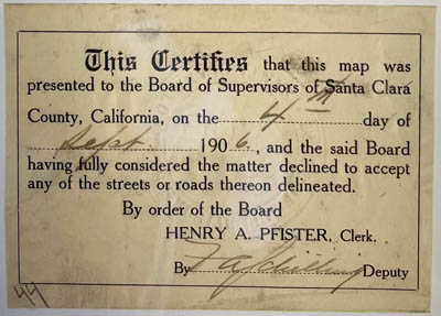 Also it should be noted that the presence of a road on such early recorded subdivision survey maps did not mean that the road existed in the physical world.
It seemed to be common for the dedication of roads for public use to be declined by the county because in many cases the roads did not exist and the county
would be responsible for building the roads if they accepted the dedication. On the right is an image that shows a certificate that accompanied another subdivision
map in the area in 1906 which indicates that this was common enough that the county had a standard certificate where they could just fill in the date and sign.
Also it should be noted that the presence of a road on such early recorded subdivision survey maps did not mean that the road existed in the physical world.
It seemed to be common for the dedication of roads for public use to be declined by the county because in many cases the roads did not exist and the county
would be responsible for building the roads if they accepted the dedication. On the right is an image that shows a certificate that accompanied another subdivision
map in the area in 1906 which indicates that this was common enough that the county had a standard certificate where they could just fill in the date and sign.