|
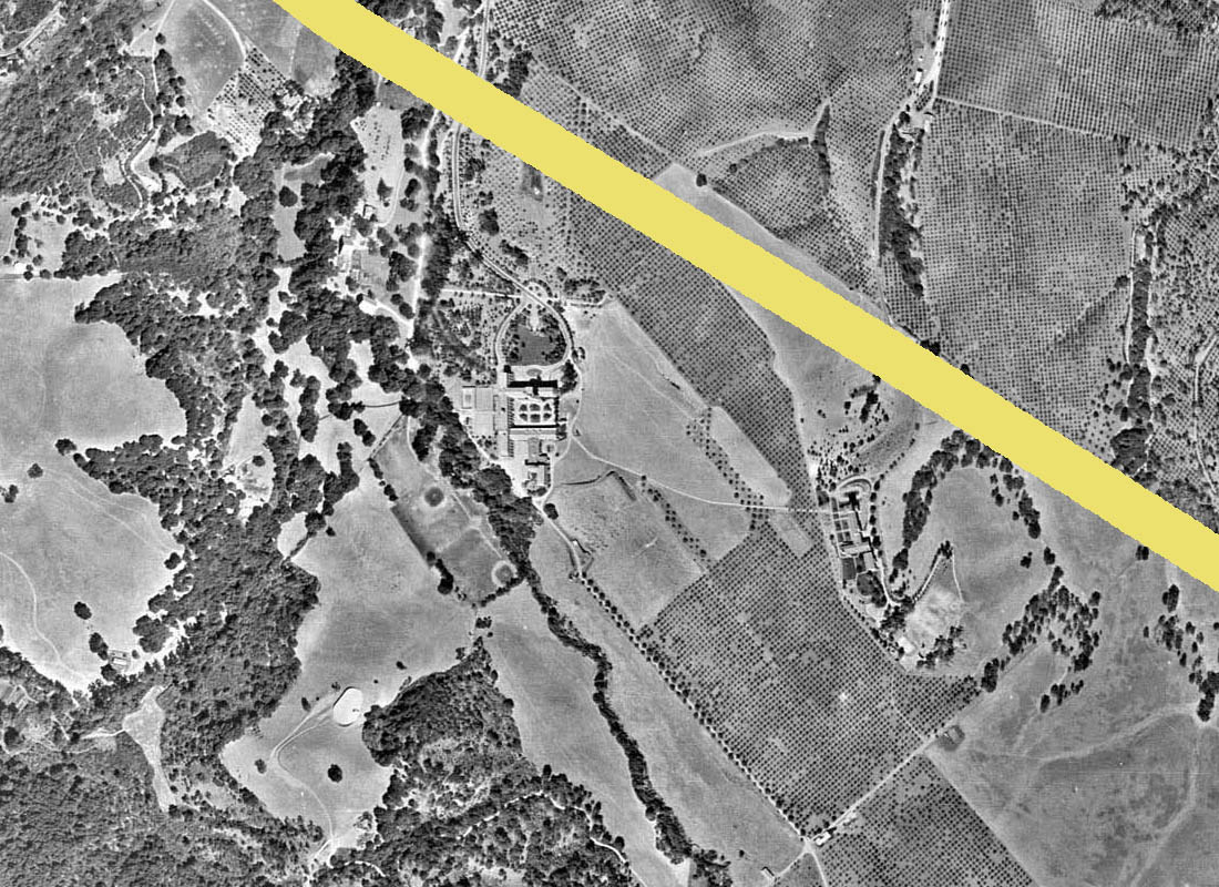
It all started as I was browsing over an old aerial survey photo of the vicinity around Los Altos and Los Altos Hills.
Below is a version of the image. It has been shrunk down in size so you can view it on your screen at a single glance to get the context and orient yourself to the region covered by the map.
The broader yellow line going from top left diagonaly to bottom right represents Highway 280 as it passes from North to South through Los Altos Hills. The highway did not exist when
this aerial survey was made (in 1947), but its approximate path has been drawn on the map to help orient the viewer while looking over the map.
Similarly, the narrower yellow line represents today's Foothill Expressway, which likewise did not exist at the time this image was captured, but the expressway follows and old railway line
which did exist at the time which made it easy to mark on the map.
The blue vertical lines at top right mark
the location of the major roads which intersect with Foothill Expressway.
.
| |
|
|
| The Aerial Survey Map - shrunk to fit completely on the screen |
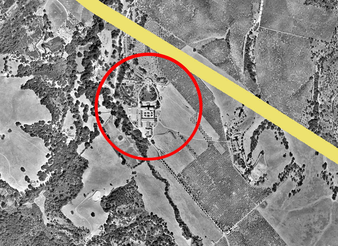
I spent some time looking at the magnified version of this map, getting oriented and figuring out where the major landmarks were. And then my eyes happened to wander down towards
the bottom right-hand corner of the map. Looking at the magnified version of the map, this is what I saw
| |
|
|
| Looking down in the bottom right-hand corner (magnified) |
The area ringed in red below is what caught my eye
| |
|
|
| The mystery area ringed in red |
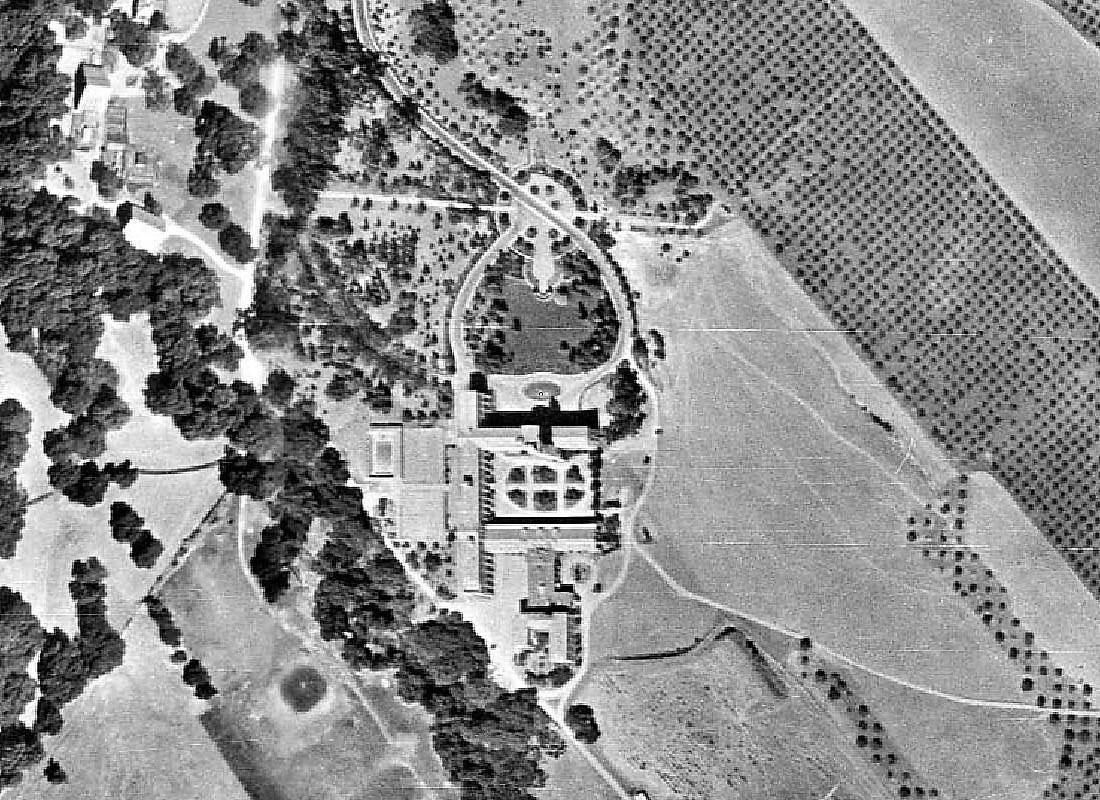
There appears to be some kind of formal tree-lined driveway coming down from the North, and leading to a large roundabout in front of some kind of large (institutional?) building - reminiscent (for example) of
something like Palm Drive at Stanford leading up the the main quadrangle - maybe not quite as grand, but certainly something more imposing than the typical ranch house of an orchard farmer.
Let's magnify it to the full resolution of the original photo taken by the aerial survey - this is the best level of detail we have
| |
|
|
| The mystery area shown at maximum resolution |
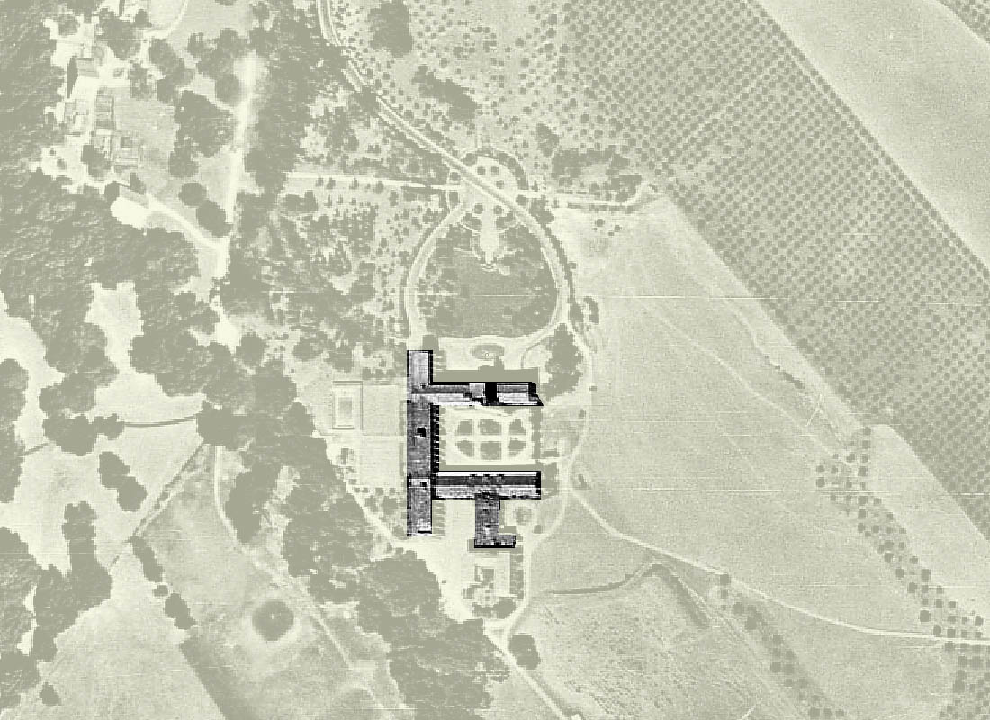
It is safe to say it is a large building - apparently consisting of a large rectangular block on the west side (left) and oriented North-South, with two rectangular wings extending toward the East.
The southern-most
of these two wings has a further extension to the south. The highlighted dark area in the following picture outlines what appears to be the main structure.
| |
|
|
| The main structure highlighted |
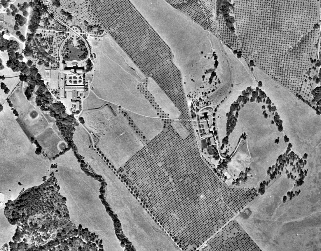
So here we appear to have a large building with multiple wings surrounded by extensive formal landscaping - located "in the county" somewhere south of the general area where Highway 280
will one day pass (remember - this aerial survey is from 1947).
There are some smaller building to the Northwest of the main structure (top left corner of the image) and an extensive
orchard to the Northeast.
Besides plenty of formal landscaping, there are a number of well-defined paths around the southern end of the building, and clearly a well-trodden path (trail? track?)
leading to the Southeast and exiting the right side of the image after passing through a narrow band of orchard. A second major path leads more directly south and exits the bottom of the image.
The big question we would like to answer - Is what piece of land are we looking at in terms of today? Where would we go to in the modern Silicon Valley to find this spot?
Maybe if we step back a bit and look at the surroundings, maybe there is a landmark of some kind that we can relate to in today's context? Let's take a look at the slightly broader area for some clues.
| |
|
|
| The broader surrounding area - Looking for distinctive landmarks |
After a bit of examination, a number of potential landmark features might be identified which then might also stick out in a more recent satellite picture, and allow us to place where this structure
was located but in terms of a more current context.
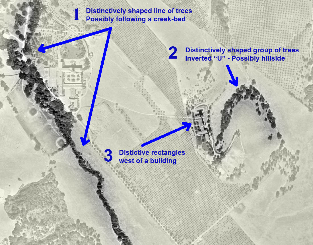
Below is the same image as the one immediately above, but now three potential features are highlighted which might be matched on a more recent satellite image.
| |
|
|
| Three distinctive landscape features selected |
Firstly we have a line of trees coming in from the top left and basically heading south briefly, before it make a slight turn more towards the South-East.
Second - we have a very distinctive grouping of trees - where the shape of the group looks like an inverted "U".
This shape of tree growth is sometimes characteristic of the shady side of a hillside,
where the climate is too hot on the sunny (south) side but just right on the shady (north) side - and where the curved contour of the hill gives the distinctive "U" shape.
And finally, we have a fairly large distinctive building on the West side of this "Inverted U" which is flanked by some darker rectangles - possibly some king of landscaping or garden feature.
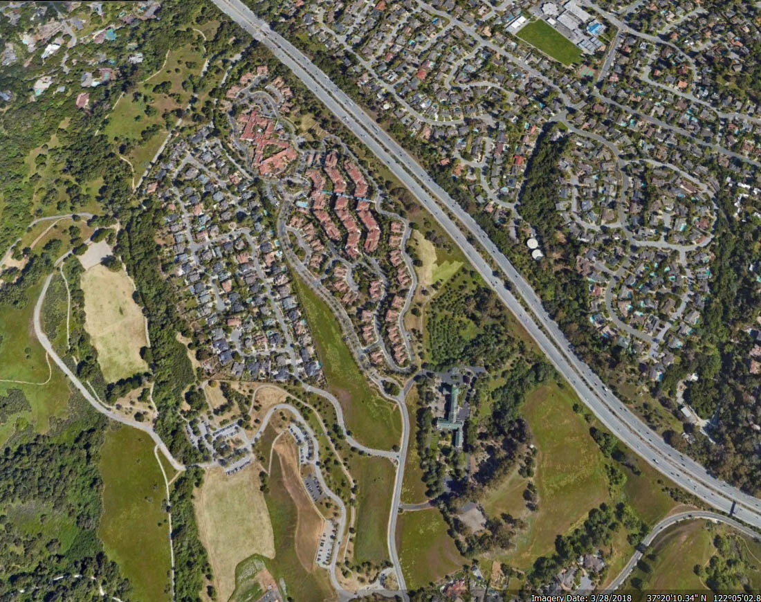
We know that the area we are lookng for is pretty close to Highway 280, probably a little south of it, and somewhere between Los Altos Hills and Cupertino. So we go to Google Maps and after some browsing around in this
area we see the following image:
| |
|
|
| Recent (2018) satellite image. Can you spot the three distinctive landscape features that we are trying to match? |
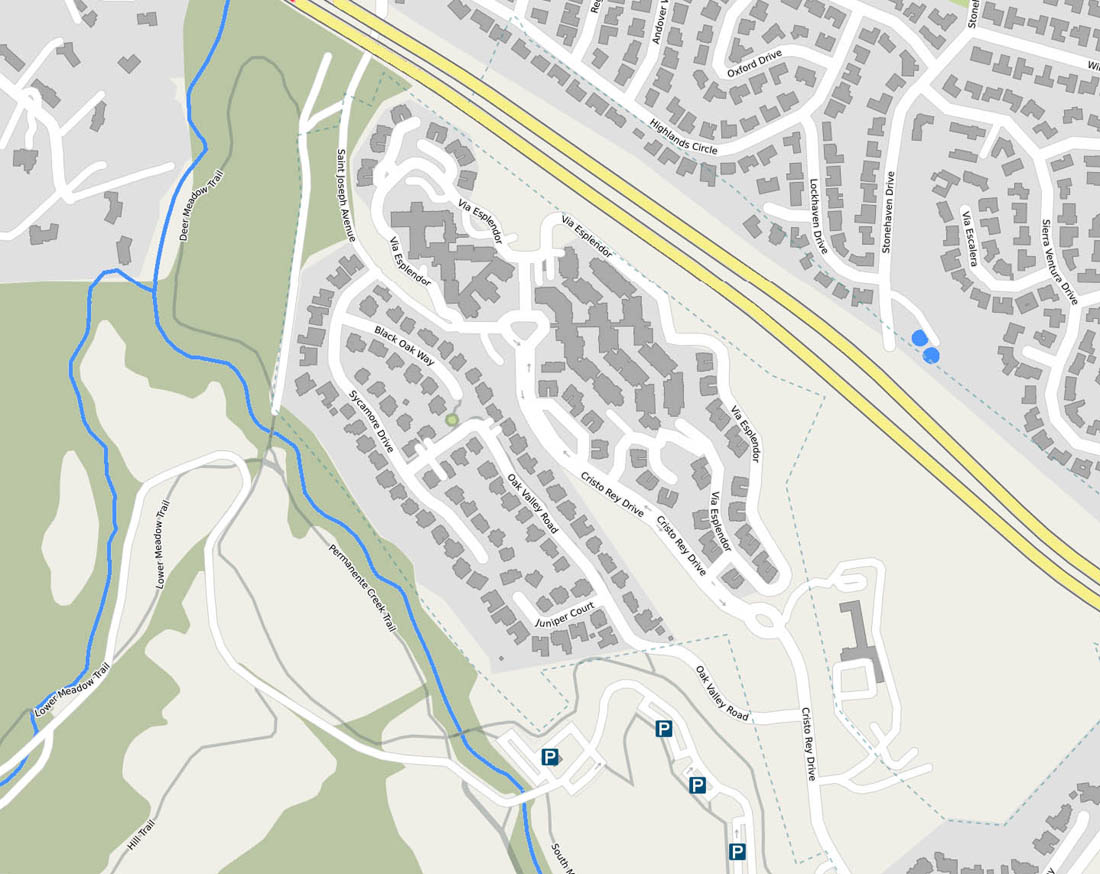
So where is this, and what would a current map show us in terms of roads, creeks, and structures? Here it is...
| |
|
|
| A map of the area showing streets and creeks and structures. |
On the left we see Permanente creek where two tributaries join before it continues flowing North to the bay. The green shading of the background tells us that the area along banks
of the creek supports dense tree coverage - and that there is a "kink" in the shape of the creek where the two tributaries come together. Just to the East of this bend in the creek is where the
mystery building once stood. But there is no evidence of any structure in that area on either this or the previous image.
To the East and slightly south, we see the large isolated building.
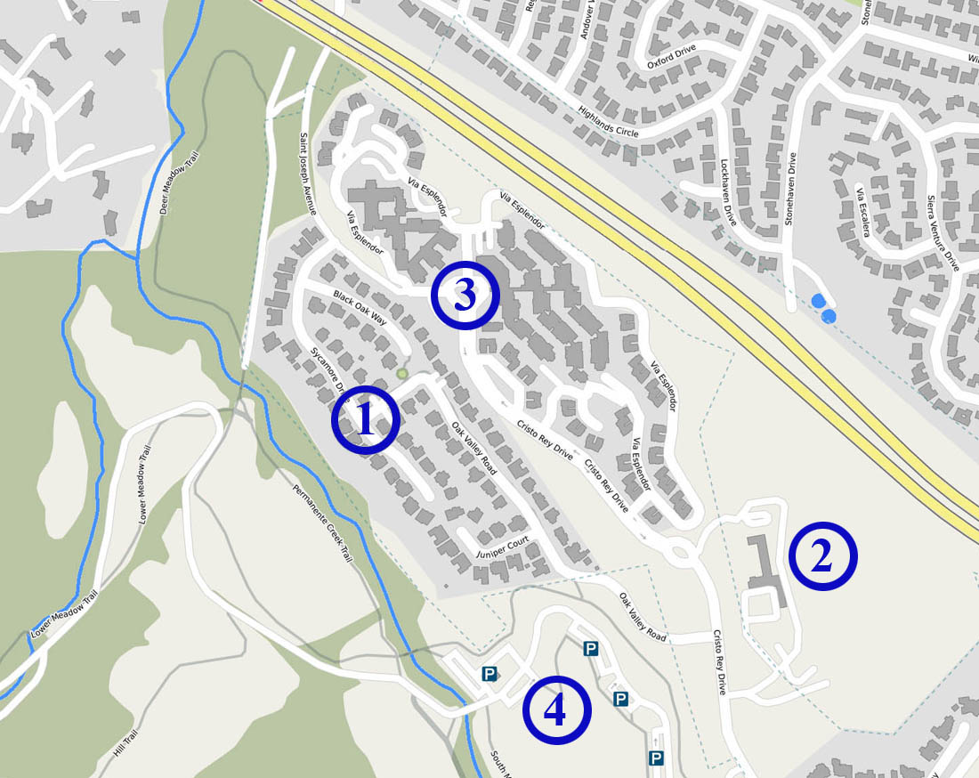
But now that we know where it is, we can recognize a number of other landmarks - referred to by the circled numbers marked on the map below
| |
|
|
| A map of the area showing streets, creeks and structures. |
- Is the approximate location where the mystery building once stood.
This is just South of the large bend in the creek, on its Eastern side and abutting the tree-line on that side
of the creek. In terms of its longitudinal position, it lies on a line horizontally a little bit North (about one building's length) of its sister building towards the East at circle number 2.
According to an alum of the disappeared institution, the main building was located "... right in the middle of the new neighborhood, between Sycamore Drive and Oak Valley Road." While this building was in what was to become a built-up
retirement community in the City of Cupertino, the athletic fields associated with the institution stretched to the West in what are now Oak-studded grassy wildlands belonging to the Mid-Peninsula
Regional Open Space District.
- Is the isolated building next to which we had the "Inverted U" group of trees to its right and the curious landscape rectangles to its left.
- Is the "Main Entrance" of the complex of buildings that make up "The Forum at Rancho San Antonio" Senior Living Community
- Is the collection of Parking areas near the main entrance to the Rancho San Antonio Open Space Preserve
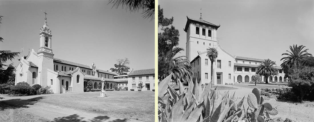
Having determined the physical location of the area depicted in this map, it is an easy matter to determine that the "isolated building" identified as Number 2 above is the Maryknoll Seminary
at 23000 Cristo Rey Drive, in what is today part of Cupertino,
Browsing the web we discover that it was built as a seminary for a Roman Catholic missionary order with missions in China
during the 1920s, and that the buildings combine elements of Chinese architecture with
Mexican Churrigueresque touches. (Library of Congress)
| |
|
|
| Maryknoll Seminary, 23000 Cristo Rey Drive, Cupertino, Santa Clara County. |
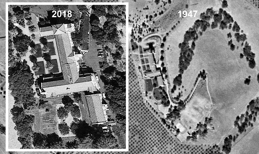
Just for fun, we can compare the satellite image of 2018 with the aerial image of 1947 and see how little has changed - except that now we can see how the "mystery landscape rectangles"
to the West of the building are in fact the quadrants formed by walkways in a larger quadrangle, each with a (by now fully-grown) palm tree in its center. (You can also see two of these
trees at the extreme right of the second picture just above.)
Note that in the more recent image immediately below, that it is the shadow of the Palm Trees rather than the trees themselves that helps us "interpret"
this picture.
| |
|
|
| Maryknoll Seminary, two views separated by 70 years |
Which brings us back to our original question... What was that large mystery building a little to the West of the Maryknoll Seminary located in what is apparently now a piece of vacant land belonging
to the Mid-Peninsula Open Space District?
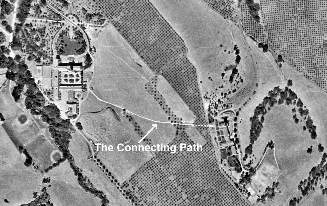
The Maryknoll Seminary gives us a clue where to look - the astute observer will have noticed in that 1947 picture that there is an apparently well-trodden pathway leading from the seminary to our mystery building.
| |
|
|
| A pathway connecting two institutions |
Googling and browsing our way some more around the Web, we find the following in Wikipedia.
St. Joseph's College was a seminary of the Archdiocese of San Francisco at Mountain View, California opened in September 1924. It was also referred to as St. Joseph's Seminary.
It was run by the Sulpician Fathers.
Its creation was supervised by Archbishop Edward J. Hanna. Hanna ordered the purchase of 700 acres and the seminary was considered "the jewel of his accomplishments."
•••
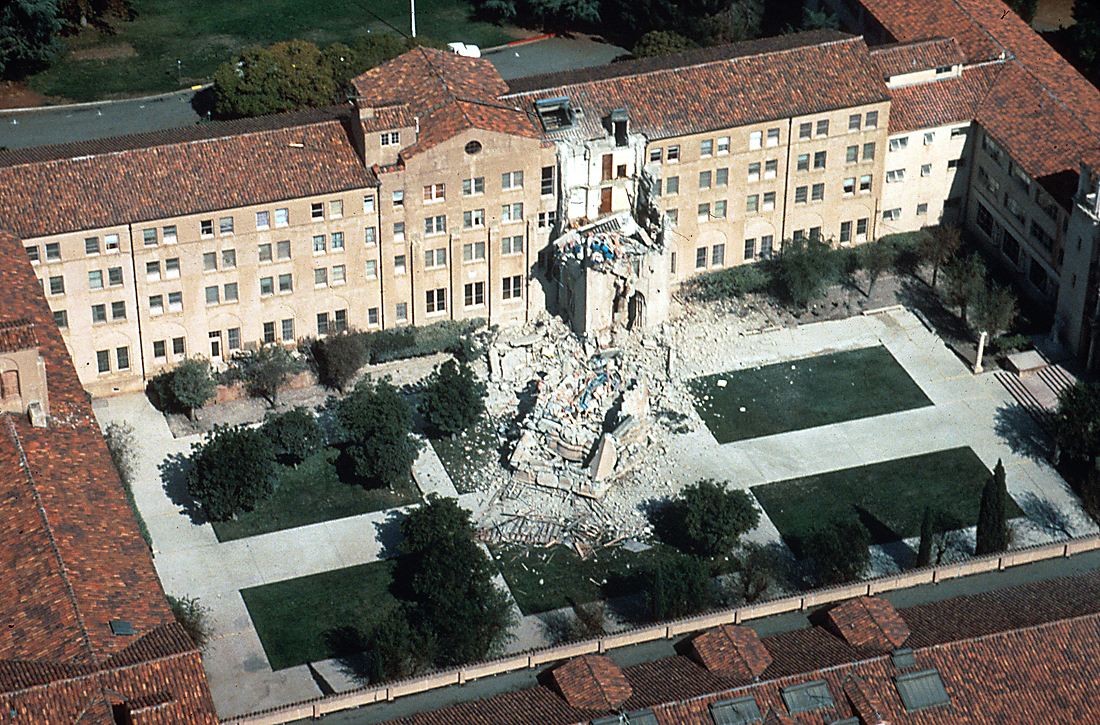
The seminary buildings were severely damaged by the Loma Prieta earthquake on 17 October 1989. The seminary was permanently closed on June 30, 1991.
The site is now part of Rancho San Antonio County Park. ••• (Emphasis added)
This text is accompanied by the following picture:
| |
|
|
| St Joseph's College - Picture taken on Oct 17 1989 by H.G. Wilshire, held in the USGS Archive Collection. |
So there we have our answer. While the main building has disappeared, and been replaced by a suburban street with individual homes in a retirement community, what is remarkable is that no trace remains
of the athletic fields that once were
associated with the school.(According to information provided by an alum, these included a couple of baseball diamonds, a soccer field, a track, handball courts and shot-put and javelin fields
as well as an old Barn.
. As seen through the eyes of an orbiting satellite in 2018
it looks like that land
is still in its original natural state.
One detail is worth remarking on. In the 1947 aerial survey, the building appears to consist of a main section running North-South with two "wings" running East-West forming
three sides of a quadrangle. However, if we look at the photograph taken in 1989 after the Loma Prieta earthquake (above), we can see that there are roofs
on all four sides of the quadrangle, thus
it looks like all four sides of
the quadrangle were enclosed as of 1989.
So it appears that there were significant additions to the original structure sometime after 1947. In this photo it appears we are looking directly at
a "Long" side of the quadrangle and with a "tower" section in the middle, and short sides at the left and right edges of the photo. This would mean that the picture was taken
looking North and that the post-1947
addition is on the right of this picture. The main driveway and roundabout would be above the top of this picture.
To confirm this supposition, we can take a look at the original image from the aerial survey, and then digitaly enlarge it to getter a better view.
Now that we have a better idea of what we are looking at, we can discern two feature details that stand out:
First, by looking
at the shadow of the front of the building (the Northern edge, facing the driveway) we can see evidence of a taller tower that is adjacent and just to the East of the raised roof section
located in the middle of this long block.
Specifically - the Northern side of the quadrangle has the ridgeline of the peaked roof running East-West, except for the raised section in the center, where the
peak of the roof ridge runs North-South. The shadow is evidence of the taller tower that once existed just to its right - and
that is shown to have collapsed in the more recent photo above.
And secondly, looking
at the roof of the South side of the quadrangle, we can see the three gables that are also evident in the photo above.
And thus it was that a chance encounter - while idly browsing over an old aerial survey image - raised a question which led in turn to the search for an answer. As is frequently the case, the search led to
learning new facts and gaining new insights into the history of our local area.
==========//==========
|
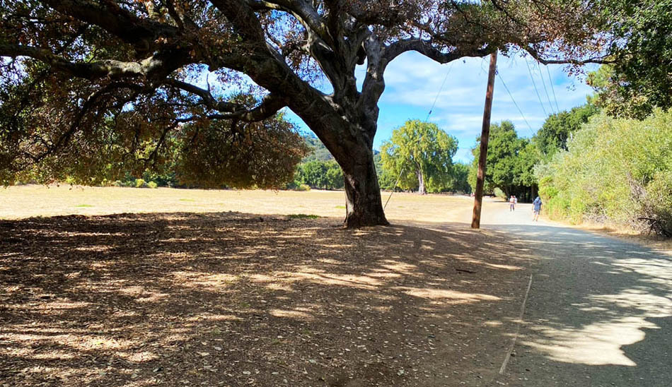
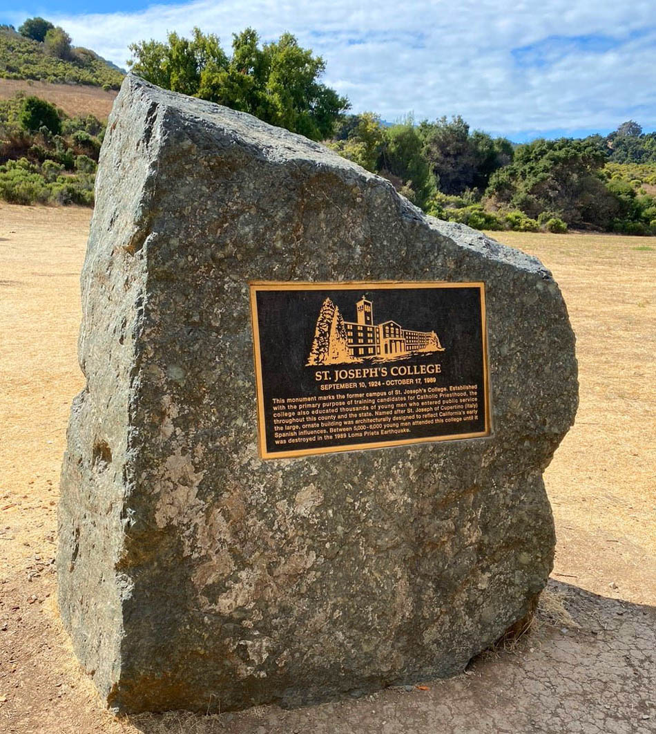
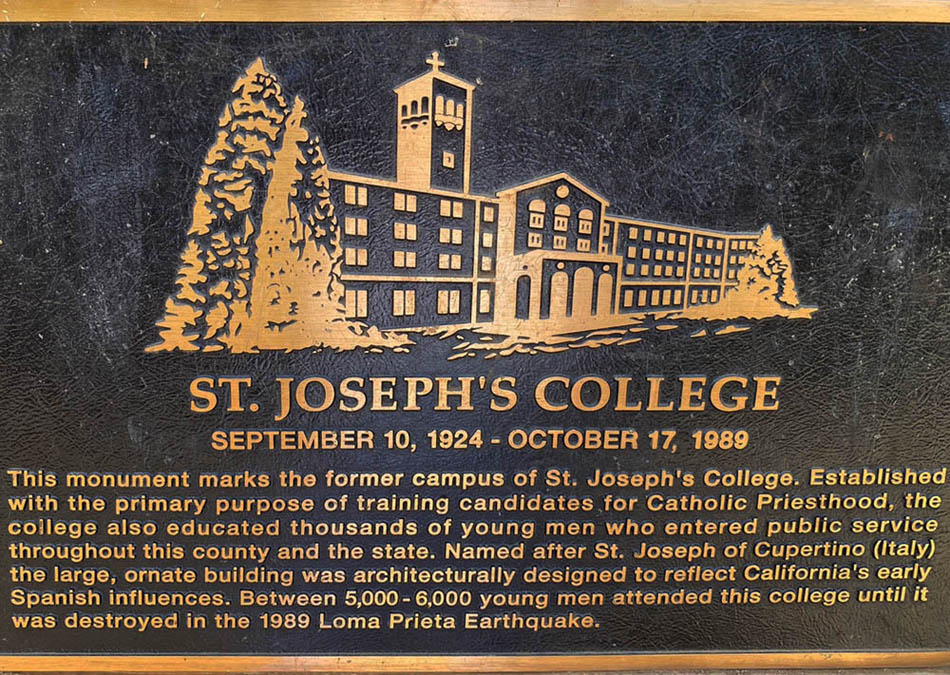
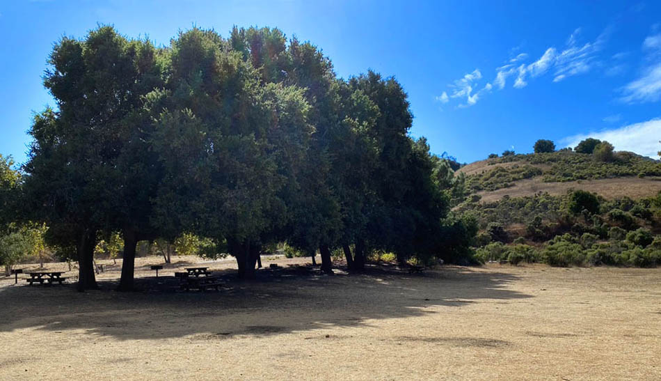
A Subsequent On-Site Visit - Ground-Truthing.
Many years after the initial version of this web-page was created, a friend took the opportunity to hike to the spot where
the college once existed, to see what it looks like today (2024).
Following are four photgraphs she took on her walk. (Photos - Courtesy Ann Duwe)
The land now is part of permanent "Open Space" owned by the Mid-Peninsula Regional Open Space District (MROSD) and a Public Pathway leads through it - seen here to the right of the tree, looking Northwards.
 |
The commemorative stone,
 |
Detailed view of the plaque on the commemorative stone,
 |
Looking roughly South-West.
 |
|
==========//==========
|
Postscript
A fellow researcher located a web-site that provided some interesting history - the relevant extract from saintjosephscollege.org is reproduced below:
A Brief History
Saint Joseph's College seminary began as a part of Saint Patrick's Seminary in Menlo Park, California, in 1898 where candidates
for the Catholic priesthood were educated in a 12–year seminary program. Due to considerable expansion in the early part of the last century,
Saint Joseph's College was built and opened as a separate school in 1924 in the foothills of Mountain View-Cupertino, California.
The program included the four years of high school plus the first two years of college education, preparing candidates for admission
to the major seminary at St. Patrick's.
The college was placed under the direction of the Sulpician Fathers, a society founded in Paris, France, and specially organized for
training of aspirants to the priesthood. St. Joseph's grew to become one of the largest college seminaries in the United States.
In 1968, St. Joseph's assumed responsibility for the four years of high school and four years of college. The high school program
was discontinued in 1980. The Saint Joseph's College seminary became a part of the newly formed Diocese of San Jose in 1981.
The seminary buildings were damaged beyond repair by the Loma Prieta earthquake on October 17, 1989. Students and faculty relocated
to a commercial building in Santa Clara for a while, but the local bishop decided to close the college on June 30, 1991.
|
|
Want to try exploring for yourself?
If after reading this account, you would like to see the complete image(s) of the area covered by aerial map used in this search, you can access them for your own browsing enjoyment
by choosing one of the following three links -
which lead to three slightly different versions of the same underlying map.
Clicking on any one of these three links will bring up the map directly in you browser - but sized to fit completely on you screen. The level of visible detail at this point is
essentialy useless except to gain a rough overall impression of the area covered.
However, if you now click on some point within the image, the browser will "zoom in" to that point of the map and display (that part of) the image at its full resolution - at whch point you
can (depending on what hardware and software platform you are using) either "drag" the image with your mouse or use the horizontal and vertical scroll bars at the edge of your screen to move around the map.
Three versions of the same basic map are available:
- The first one is a ".jpg" file with "medium" resolution, resulting in a manageable file size of.5.45 Mbytes. The image size you get to see in your browser is 5000-by-4500 pixels.and
there are a few landmarks (annotated with colored dots) to help you orient yourself. You can access this version
by clicking
 . .
- The second one is similar to the above, but has more landmarks annotated, which makes it much easier for the beginner to find their way around. Specifically the general path of Highway 280 is shown
and the border of the Town of Los Altos Hills is marked. In addition, the areas under orchard cultivation (in 1947) are lightly shaded in green.This is probably the best version of the
map for the beginner as it combines
a moderate file size with sufficient resolution for most purposes, and has the extra annotations on the map to help you find your way around. You can access this version by
clicking .
- The third version is only recommended if you already have some experience using one of the first two and have some familiarity in navigating your way around. This is the "Full" resolution version
of the map - the image is 9000-by-8000 pixels and the file itself is a little over 15 Mbytes. This means not only that it may take a little while for the file to download into your browser, but
it may also bring your computer to its knees in terms of sluggish responsiveness in dealing with this large a file. This version is only worth accessing if you really need the extra resolution.
You can access this version by clicking
And it should go without saying - you need to use a computer with at least a decent-sized screen to do this. Don't even try this on your cell-phone...
Furthermore - if you think you might make a habit of this behavior, you might just want to download the map once and for all on to your computer. You can achieve this by doing a "right click" on the
desired link, followed by responding to the subsequent "Save image as..." menu-item.
|
|